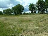
This sector is the south-western part of the Defence Line.
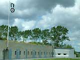
 Sector depot Sloten, Materials Division Sector depot Sloten, Materials Division
Located along a side canal of the North Sea canal near the village Halfweg. Used for the storage of artillery and other materials.
Partly dismantled except a official residence and two sheds for vehicles from 1937.
 Show map Show map
|
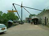
 Sector depot Sloten, Ammunition Division Sector depot Sloten, Ammunition Division
Built in 1898 for the storage of ammunition and explosives for the Sector Sloten.
(Also named "1800 Roeden"; roeden is an old linear measure, 1800 Roeden is measured from the Haarlem city gate in Amsterdam)
Show map |
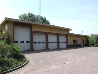
 Group Depot Halfweg no. 1 Group Depot Halfweg no. 1
Built in 1905 it consists of a house and a shed, both made from wood. Most were intended to be built in wartime. This depot is one of few built and completely intact.
These depots were lowest level of the logistics from the central depots to the forts.
Show map |
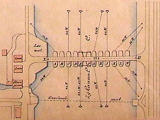
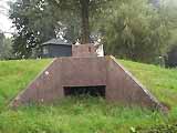
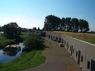
 Side Canal B Casemates Side Canal B Casemates
This side canal of the North Sea canal is the main part of the Defence Line between two forts. In 1934, two casemates were constructed to close the road access along the canal. The canon casemate was demolished so only the machine-gun casemate remains.
Show map |
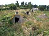
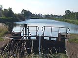
 Pontoon Bridge Side Canal C Pontoon Bridge Side Canal C
A pontoon bridge planned to cross Side Canal C (behind B) was to be part of a system of military roads. On one side of the canal, the joists, planks, anchors and tools for assembling the bridge were stored in two engineers' sheds.
Although a pontoon bridge was planned and prepared at two other locations, this is the only location where the sheds were not on the area of a fort.
Show map |
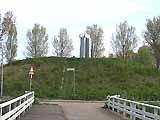
 Position at Spaarndam Position at Spaarndam
Defences West of Spaarndam, consisting of two forts, a rampart with two secondary batteries and concrete shelters in and in front of the rampart. Spaarndam had important inlet sluices and was an important route to Amsterdam. The rampart dates from 1809 and the defences improved until 1960.
Show map |
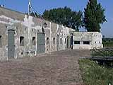
 Position at Spaarndam - Position at Spaarndam -
Fort north of Spaarndam
Completed in 1901 as part of the Position at Spaarndam. Has one of the few remaining access bridges in the Defence Line. In 1903 a secondary battery was built south of it, which is now covered-over with ground.
Show map |
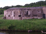
 Position at Spaarndam - Position at Spaarndam -
Fort south of Spaarndam
Also completed in 1901 as part of the Position at Spaarndam. Its access bridge was replaced by a dam like with many other bridges. In 1903 a secondary battery was built north of it and is still visible.
Restored in 1998-1999, including a new bridge.
Show map |
 Position along the Liede Position along the Liede
This consisted of three forts, a connecting rampart and a few earth- and concrete- secondary batteries. There were also some concrete shelters of which only one remains. Part of the original military road behind the earth rampart still exists.
Show map |
 Position along the Liede - Position along the Liede -
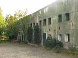
Fort near Penningsveer
Built between 1898 and 1901 for 295 soldiers. Nearby sluices are still present, along with a secondary battery north of the fort.
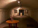
Now in use for educational and youth camps.
Show map |
 Position along the Liede - Position along the Liede -
Fort near the Liebrug
Completed in 1900 to defend the Haarlem - Amsterdam railway. Has a small fort with only one gorge-side casemate.
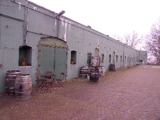
Now in use as storage and distribution centre for the transport of valuables.
Show map |
 Position along the Liede - Position along the Liede -
Fort along the Liede
A tower fort of the Defence Line's predecessor was built in 1843 but partially demolished (lowered) in 1885 and further demolished in 1914-1919. We believe the lower level is still present below ground.
It lies partly in the Circular Canal of the Haarlemmermeer polder to effectively block water traffic.
Show map |
 Fort near the Fuikvaart Fort near the Fuikvaart
Only "built" on paper (1904, 1906, 1911-1915) but never constructed because of the Great War. Early drawings show plans for a fort very similar to the Fort near Hoofddorp, whereas later plans show a smaller fort. Sources indicate a battery was located here during the Great War. The purpose of the fort/casemate/battery was to increase defences and to protect a nearby dam sluice.
Show map |
 Rampart between Fort along the Liede and M.P. 19, also Casemate M.P. 20 Rampart between Fort along the Liede and M.P. 19, also Casemate M.P. 20
Alongside plans for a Fort near the Fuikvaart were plans for a 2.7 km rampart between Fort along the Liede and mile stone 19 near the village of Vijfhuizen. Because of the Great War it was never constructed. It would have eight batteries, one casemate and three cut ditches for roads. The casemate would have been similar to one previously designed and planned near mile stone 20.
Show map |
 Fort near Vijfhuizen Fort near Vijfhuizen
One of the first concrete forts built of the Defence Line. Completed in 1899 with an iron military shed from 1896, which is the only remaining one.
To the southwest were two areas with shelters for troops retreating into the Defence Line. Behind the fort was the Military Tree Nursery.
Show map |
 Fort near Vijfhuizen - Fort near Vijfhuizen -
Advanced Defence at Vijfhuizen
One of the oldest locations with a reinforced concrete construction; model 1916 shelters which were built in 1917 and 1918. They would provide shelter from enemy fire while men retreated into the Defence Line. Also has five machine gun blocks.
Show map |
 Fort near Vijfhuizen - Fort near Vijfhuizen -
Advanced Position near Heemstede
On the site of an older fort, here too were reinforced concrete shelters built in 1916. They had the same purpose as those of the Advanced Defence at Vijfhuizen.
Show map |
 Engineers' dike through the Haarlemmermeer polder Engineers' dike through the Haarlemmermeer polder
The large Haarlemmermeer polder was split into two by an engineers' dike about 15 kilometres from the centre of Amsterdam. Built between 1890 and 1895 it is 10.5 kilometres long and it allowed the southern half of the polder to be inundated while the remaining half stayed dry.
Show map |
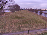
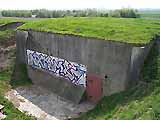
 Battery along IJweg Battery along IJweg
To support the two forts on either side, a 'mini fort' was built in the engineers' dike in 1906. It was similar to the Battery along Sloterweg but is not visible anymore.
Only a hill of earth persists, most likely covering the remains.
Show map |
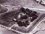
 Fort near Hoofddorp Fort near Hoofddorp
In the middle of the Haarlemmermeer polder and the Engineers' dike, this fort was built between 1903 and 1904. Because of limited space and the depth of the polder, a two level bomb proof building was built with a deep moat and a special machine gun post to cover the deep moat.
Show map |
 Battery along Sloterweg Battery along Sloterweg
The only remaining 'mini fort' which supports the two forts on either side. Built in 1906, it could only cover the flank with guns and not the front.
Show map |
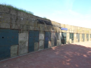
 Slotertocht Casemates Slotertocht Casemates
As specified in the State Road Plan of 1926, Highway 4, between The Hague and Amsterdam crosses the Engineers' dike, which has the undesired effect of adding an extra access point into the Defence Line. Three concrete casemates, for one canon and two machine guns, were built in 1934 to defend this access.
Show map |
 Battery along Aalsmeerderweg Battery along Aalsmeerderweg
An earth battery, used to close the 'Aalsmeerderweg' road. A recent shed was built and demolished.
Show map |
 Lift-lock near Aalsmeer Lift-lock near Aalsmeer
Built in 1891 and used until around 1957, this double lift-lock is the largest of the sluices built for the Defence Line. In wartime it was used for the inundation of the large Haarlemmermeerpolder. In peacetime it was the only direct connection between the polder and the outside waters and used heavily to transport vegetables to Amsterdam and sugar beet to the factory in Halfweg.
Show map |
 Fort near Aalsmeer Fort near Aalsmeer
Completed in 1904 with a double wet moat and two sluices at the gorge side.
Show map |
 Fort along the Schiphol Fort along the Schiphol
Completed in 1851 as part of the predecessor of the Defence Line. The tower fort was not demolished until 1935. Next to it was the Military Airfield Schiphol since 1916 which later became a civil airfield, Amsterdam Airport Schiphol.
Show map |
 Fort near Kudelstaart Fort near Kudelstaart
Built between 1906 and 1907 to defend the lake Westeinderplassen and its dike.
Now in use as a yachting-club for (retired) military personnel.
Show map |
|

")